

Over the long winter months in Ottawa, I was researching popular day hikes around the area. That’s when I found the ADK 46 challenge – meaning to summit all 46 High Peaks of the Adirondack Mountains. I knew I couldn’t hike the more challenging, lengthy trails, so I looked for the trails that were shorter in length. I was also coming down on Memorial day, so I knew I needed to avoid the popular routes. I settled on the Street and Nye hike – it’s unpopular, short and doesn’t have the most rewarding views.
I drove down Friday night, got to the trail head, and learned two things 1) I needed American cash 2) Sleeping in cars is prohibited. So I drove back to Lake Placid, withdrew money from an ATM and found a nice parking spot away from the bars.
The sun came up around 6 am. which is I drove to the trailhead at the ADK LOJ. It was a good thing I got there early – the parking lot was almost full.
The trail is not maintained but it was clear where to go. The only unclear section was near Indian Pass Brook which you must cross.
 Indian Pass Brook.
The crossing was quite slippery as the water level was over most of the rocks. The hike to the top is very gradual with no really steep sections. The intersection between Street and Nye is really big and open – a great place to take a nice lunch break. I summited Nye Mountain first.
 Top of Nye Mountain (3890ft).
On my way up to Street Mountain, there were sections of snow and ice which I thought was surprising for the end of May. The views from Street Mountain were wooded also.
 Top of Street Mountain (4150ft).
The views got better a few meters further.
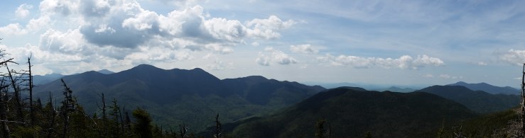 Close to the top of Street Mountain
On my way back, I slipped on a rock crossing Indian Pass Brook and banged my knee pretty badly, so I decided not to go to the top of Mount Jo even though I had the energy for. Driving back, there was about a kilometer of cars parked on the side of the road. Again, I’m glad I got there early!
Click on the  icon to make the Google Map full screen, to see all the photos I took and where they were taken. Click on the
  symbol to see all the photos. There are 4 in total.
Stats:
13.0 km total distance
795 m of elevation gain

Great blog you have herre
LikeLiked by 1 person