

Josée and I go on an annual canoe trip. Our trip to Killarney last year was a little too cold and buggy, so this year, we pushed our trip back a week – to the second week of July. We also wanted to change up our food. So the day before our trip, we dehydrated a bunch of fruit, veggies and some ground beef.
 All our stuff and Josée at Widgawa Lodge.
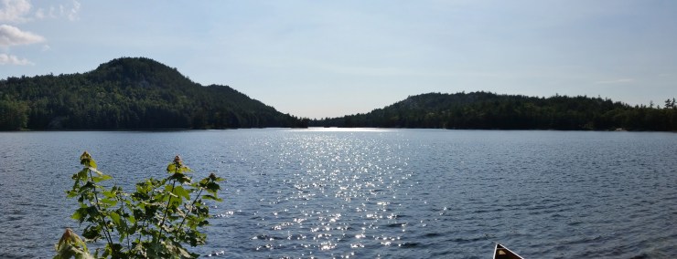
Day 1: We set off from Widgawa Lodge along the Marsh River, which spits you out into Charlton Lake. From Charlton Lake, it’s a short paddle to Frood Lake. Looking east on Frood Lake is your first real look at the beautiful La Cloche Mountains. The white quartzite is hard to miss, even from kilometers away.
 Josée on Frood Lake. In the distance, Killarney Provincial Park.
A 6.5 km paddle on Frood lake brought us to the first portage. The portage was a little wet but fairly flat. From the portage, we made it to Grace lake. We paddled around a little and found a really cool site on a peninsula.
 View from our campsite on Grace Lake.
For dinner, we made steak, potatoes and veggies on the fire. We went for a swim then shared a beer while watching the sunset.
Day 2: We woke up, packed up and had pancakes for breakfast. I headed off for a short solo hike to check out the location where the famous “Carmichael’s Rock” photograph was taken.
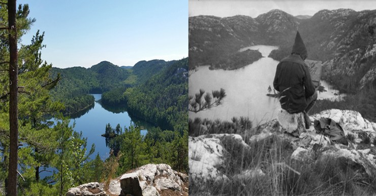 Carmichael’s Rock.
After checking out Carmichael’s Rock, we paddled to the portage from Grace Lake to Carmichael Lake. After a 2 km portage, we had made it to Carmichael Lake.
 The first view of Carmichael lake. In the distance is where A Y Jackson painted the famous “Nellie Lake” painting.
It was a 1.5 km paddle from the portage to campsite 141.
 Top: above campsite 141. Bottom left: campsite 141. Bottom right: Swimming in Nellie Lake.
Our main reason for picking this site was to check out where A. Y. Jackson painted “Nellie Lake”. It was roughly a 1 km round trip hike from the site.
 This is the best photo I could get that looked like the painting. “Nellie Lake” was painted in 1933.
After the hike, we went for a swim and another short paddle around the lake. We made a small fire and ate dinner: veggies and sausages on buns.
Day 3: It had clearly rained overnight and was looking pretty overcast. We packed up our stuff and said goodbye to our site. We set out on a 1.6 km paddle to “The Notch” portage. The portage was either a steep 1.4 km up hill or downhill. Luckily for us, Nellie Lake flows into Murray Lake. The cover photo is a panoramic of “The Notch” portage. You can see Murray Lake in the distance, and even further Leech Lake. The portage took us just under 2 hours.
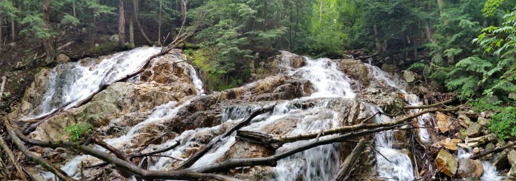 Waterfall just off “The Notch” portage.
After the portage and a short paddle to the other side of Murray Lake, Josée did a little bit of fishing. The 1 km portage from Murray Lake to Leech Lake was very muddy, ending in a swamp just a few meters away from a campsite.
Leech Lake is mainly crown land, so all the sites are first come, first served and you can stay there for a maximum of 21 days. Josée did a little more fishing on Leech Lake. After a few casts, we paddled 2.7 km to the end of Leech Lake.
Then we had a 150 m portage to Hanwood Lake. Just as we were loading our stuff into the canoe, Mother Nature decided it was time to relieve the clouds of their burden. They were some heavy clouds too. The 2.7 km paddle on Hanwood Lake to the portage felt like we’d traveled back in time to spring. We attempted to take refuge from the rain and wind in a little inlet, but the trees weren’t big enough to shield us. Next came an almost vertical 90 m portage to Van Winkle Lake.
From there, it was only a few hundred meters to our campsite on an island. We were wet and cold, and we forgot to bring a tarp. So we hid under our canoe while we unpacked the tent. Just as we finished setting up the tent and were ready to make our food, the rain stopped. After dinner, we hid in our tent, sheltering ourselves from the wind for the rest of the night.
Day 4: We woke up to the same blistering wind we fell asleep to. We packed up our stuff and paddled off.
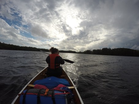 Paddling on Van Winkle Lake.
It was a 2.5 km paddle on Van Winkle Lake to the portage to Cat Lake. The portage was pretty flat and just a little wet from the night before. About 480 m later, we arrived at Cat Lake where we watched a helicopter land near an old cabin. After a 400 m paddle across Cat Lake, we arrived at our next portage: a 715 m portage to Howry Lake. The portage had rolling hills that were super wet. The wind was blowing west at this point, and luckily, we were paddling west for the remainder of the day. A kilometer down Howry lake, it narrowed down into a decently fast moving creek. After hitting a beaver dam 2.2 km from the previous portage, we had to portage again – a 445 m distance along the creek.
 The end of Howry Creek portage.
After a 4.4 km paddle along the second section of Howry Creek, we were at our campsite. We checked out campsites 156 and 149 and settled on 148. The sun came out in full force. We had enough time to lay out all our stuff to dry and go for a swim. We had Hamburger Helper for dinner with our dehydrated ground beef.
 Left: A massive turtle. Right: Josée caught a pike.
Day 5: We woke up to another grey day. Josée did some fishing along our 2.2 km paddle to the only portage of the day which was along Howry creek. The portage was quite short (185 m), but the last 10 m were flooded. The rest of the day went quite smoothly.
 The view during our lunch rock.
Click on the  icon to make the Google Map full screen, to see all the photos I took and where they were taken. Click on the
  symbol to see all the photos. There are 71 in total. I colour coded each day. Blue is day 1, burgundy is day 2, pink is day 3, yellow is day 4, and purple is day 5.
Here’s a video I took of the trip. Thanks to Troy Huizinga for providing the soundtrack again. https://www.youtube.com/watch?v=RRyNjRNji9A
Stats:
Day 1: 5 km portaging (2 trips), 11.4 km paddling
Day 2: 0.8 km hike to Carmichael’s Rock, 5.1 km portaging (2 trips), 2.2 km paddle 0.9 km hike to where A.Y Jackson painted “Nellie Lake”
Day 3: 8 km portage (2 trips), 6.5 km paddle
Day 4: 4.7 km portage (2 trips), 11.5 km paddle
Day 5: 500 m portage (2 trips), 15.1 km paddle
Total: 23.3 km portaging, 49.6 km paddling, 1.7 km hiking
